Compact Multispectral Camera LiDAR Scanning System For Forestry
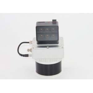
gAirHawk GS-130D is a kind of short-range, compact LiDAR point cloud data acquisition system, integrated HESAI XT laser scanner, GNSS and IMU positioning and attitude determination system, and storage control unit, is able to real-time, dynamically, massively collect high-precision point cloud data and rich image information. It is widely used in the acquisition of 3D spatial information in forestry, agriculture.
Pandar XT
High precision. Minimum range of zero.
Proprietary LiDAR ASICs.
32-Channel Short-Range Mechanical LiDAR

Specification
| gAirHawk GS-130D | | | Item Name | System Parameters | |
GS-130D
Parameters | Weight | 1.6 kg | | Measuring accuracy | Less than 0.1m @120m | | Working temperature | -20℃~+65℃ | | Power range | 12 V- 24 V | | Consumption | 10 W | | Carrying Platform | GS-800 Multi Rotor and Other brand | | Storage | 64 GB storage, maximum support 128GB TF card | | Lidar Unit | Measuring Range | 0.3m-120m@10% Reflectivity | | Laser class | 905nm Class1 (IEC 60825-1:2014) | | Channel | 32-Channel | | Range accuracy | ±1cm (typical Value) | | Scanning frequency | 10HZ, 20HZ | | data | Double echo 1,280,000 Points/Sec | | FOV | 360°, adjustable | | Laser sensor | HESAI XT | | POS Unit | Update frequency | 200HZ | | Heading accuracy | 0.017° | | Pitch accuracy | 0.005° | | Rolling accuracy | 0.005° | | Position accuracy | ≤0.05m | | GNSS signal type | GPSL1/L2 GLONASSL1/L2 BDS B1/B2a/B3 | | POS | AGS 303 | | Pre-processing software | POS software | Output information: position, speed, attitude | | Point cloud software | Output point cloud data format: LAS format, custom TXT format | | Multispectral Camera | FOV: HFOV:49.6 °, VFOV:38 °
Weight (g): 275 g
Focal Length (mm) : 5.2
Typical Width: 110m*83m@AGL=120M Resolution: 1280*960
Ground Pixel Resolution: GSD: 8.65/Pix, AGL:120
| |
Application for Forestry & Agriculture
Package
It is packed by suit case with EVA material liner inside, then covered by hard carton box. It is suitable for air shipment and sea shipment.